THE GRAND STAIRCASE WILDERNESS
- No Mans Mesa -- An Ecological Wonder
- Islands of Biological Diversity
- Wilderness -- the Best Ecological Medicine
- Strip Mines, Power Lines, and Railroads
- Vehicle Corridor -- or Wilderness Refuge?
- PARIA-HACKBERRY UNIT
- BRYCE ADJACENT UNITS
- THE BLUES UNIT
- MUD SPRING CANYON UNIT
- THE COCKSCOMB UNIT
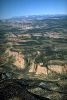 Between the floor of the Grand Canyon and the rim of Bryce Canyon, the land rises 7,000 feet in a series of great cliffs and plateaus. This is the "Grand Staircase," a masterpiece of geologic and biological innovation, a world where time itself lies suspended in horizontal and vertical planes. Its huge stairway spans six major life zones, from Lower Sonoran desert to Arctic-Alpine forest. Its colorful rock formations contain some four billion years of geologic history, and its fossils are a biography of life on Earth.
The Grand Staircase forms a nearly continuous wall winding 100 miles across southern Utah, from Zion National Park to Glen Canyon National Recreation Area. Yet only one section of the Staircase -- the rugged canyon country of the Paria River basin -- remains wild from top to bottom. Here lies our best opportunity to preserve, unaltered by man, a complete vertical cross-section of this remarkable landform. Yet the BLM's fragmented wilderness recommendations would leave unprotected 168,000 acres throughout the Paria River basin, permitting a host of developments including coal mines, oil fields, truck haul roads, a railroad corridor, a dam and reservoir on the Paria River, off-road vehicle corridors, and thousands of acres of forest chainings.
 By contrast, the Utah Wilderness Coalition seeks wilderness designation for 268,300 acres, encompassing all five BLM roadless units lying between Bryce Canyon National Park and the newly designated Paria Canyon Wilderness. From its headwaters to its mouth, the Paria watershed is one wilderness. Only by protecting all of the wild country surrounding the Paria River, can we hope to keep it that way.
No Mans Mesa -- An Ecological Wonder
On a warm, hazy, golden afternoon in November of 1985, two National Park Service employees entered a clearing in the pinyon-juniper forest on top of No Mans Mesa. At the center of the clearing Norman Henderson, a grazing specialist at Capitol Reef National Park, dropped to one knee. Noel Poe, the park's chief ranger, peered over Henderson's shoulder. Smiling with satisfaction, Henderson examined the flora surrounding him, fingering leaves, stroking seed pods, and softly naming each plant. "Manzanita," he muttered. "Aster. Muhley grass. Poa, buckwheat, dropseed, ricegrass . . ."
| But the eastern and northeastern view is one which the beholder will not easily forget. It is the great amphitheater of the Paria . . . . An almost semicircular area, with a chord 30 miles in length, has been excavated into a valley by numberless creeks and brooks, which unite into one stream named the Paria.
Clarence Dutton |
For Henderson and Poe, the 150-mile journey from Capitol Reef National Park to No Mans Mesa had been a professional pilgrimage. Henderson was conducting a major study of the effects of livestock grazing within Capitol Reef National Park. He had come to No Mans Mesa in search of a relict plant area to serve as a baseline for the study. Sadly, no such area could be found within Capitol Reef National Park.
Islands of Biological Diversity
It is indeed ironic that undisturbed plant communities cannot be found within a national park. But recent studies suggest that animal species are also vanishing from our national parks. A 1987 study by ecologist William D. Newmark, for example, cited 42 cases of extirpation of mammal species in 14 North American parks. Many of our national parks, Newmark concluded, are islands of biological diversity surrounded by a sea of developed land. Like the land-bridge islands of the Aleutian archipelago, these protected areas are simply too small to support species of wildlife once common to them.One of the parks Newmark studied was Bryce Canyon, just 10 miles northwest of No Mans Mesa on the eastern flank of the Paunsaugunt Plateau. For all its natural splendor, Bryce Canyon has been slowly losing its wildlife. The red fox has not been seen there for 28 years. The pronghorn antelope, the beaver, and the northern flying squirrel have all vanished since the park was established in 1924.
In lands bordering the park, livestock forage competition and hunting pressure has reduced or eliminated the populations of certain large mammal species. "Bears, once common on the Paunsaugunt Plateau, seem to have been exterminated," wrote geologist Herbert Gregory in 1951. "No grizzly bear has been reported during the last half century, and only three brown [black] bears are known to have visited the region since 1920. Wolves and coyotes, the bane of the stockman, have been so reduced in numbers as to be no longer a serious menace. Beavers, formerly abundant, have been exterminated by trappers. Of the `great herds' of elk, antelope, and deer that provided food and raiment for the Indians and the Mormon pioneers, only the mule deer remains . . . ."
Wilderness -- the Best Ecological Medicine
This steady decline of wildlife species is not inevitable. In recent years, better management practices have begun to curb overgrazing and overhunting, and the Utah Department of Wildlife Resources has been systematically reintroducing native wildlife species throughout Utah. The Department has recently established an elk herd just north of Bryce, and antelope to the south. But the success of such programs is directly dependent upon the amount of undisturbed wildlife habitat. As the Newmark study suggests, to survive, many wildlife populations need habitat of sufficient size and diversity.
| The bottom and the top of the "stairs" of the Grand Staircase wilderness are already protected within Bryce Canyon National Park and the newly established Paria Canyon Wilderness Area. But the heart of this region -- the upper Paria canyon system -- remains unprotected. Wilderness protection for this vital "missing link"is the key to the scenic, recreational, and biological integrity of the entire Grand Staircase wilderness. |
For humans, too, the Grand Staircase wilderness provides exceptional habitat. Its scenic and recreational opportunities are superb, and its cliffs and canyons are a museum of earth history. The region has recently inspired several books, including a hiking guidebook which features more than 300 miles of backcountry routes in the Paria wilderness. As National Geographic editor Ralph Grey observed (in Geerlings, 1980), a journey down the Grand Staircase -- descending from arctic-alpine to Sonoran desert habitat -- is a reenactment of human as well as geologic history. "Travel the mere 90 miles to the depths of Grand Canyon from the lofty plateaus of Bryce," he wrote, "and you are experiencing in compressed space and time the migration of the Ice Age people -- the first Americans -- from the Alaska land bridge to the tropics."
The bottom and the top "stairs" of the Grand Staircase wilderness are already protected within Bryce Canyon National Park and the newly established Paria Canyon Wilderness Area. But the heart of this region -- the upper Paria canyon system -- remains unprotected. Wilderness designation for this vital "missing link" is the key to the scenic, recreational, and biological integrity of the entire Grand Staircase wilderness.
Strip Mines, Power Lines, and Railroads
Unfortunately, the BLM's wilderness recommendations would shatter the integrity of the Grand Staircase wilderness. Of 268,000 acres of BLM wild lands in six roadless units, the BLM is likely to recommend wilderness for only 100,000 acres -- leaving most of Paria basin wild lands wide open for development.To understand why the BLM has recommended against wilderness protection for more than half of the Grand Staircase wilderness, one must turn the clock back to the mid-1970s. In 1976, during the energy crisis brought on by the Arab oil embargo, four giant utility and energy companies launched a proposal to strip mine coal on 25,000 acres of land south and west of Bryce Canyon National Park. Still more coal development was proposed for the northern rim of the Paria River basin, and for the Kaiparowits Plateau to the east. To transport coal, mine equipment, electrical power, and personnel, the developers drew plans for a network of slurry pipelines, truck haul routes, railroads, and transmission lines crisscrossing the entire region. A 1980 BLM study (ERT, 1980) identified six potential coal transportation corridors linking the Alton, South Kaiparowits, and North Kaiparowits coal fields. Four of the six corridors crossed parts of the Paria River basin.
Meanwhile BLM range specialists were developing ambitious proposals for "vegetation treatments," such as chaining, burning, spraying, plowing, and seeding, on up to 100,000 acres of land within the Paria River watershed (BLM, 1980). With local rangelands seriously depleted by overgrazing -- and the expected loss of more than 8,000 acres of rangelands to strip mining -- the agency was searching for ways to increase livestock forage. Its solution was to remove thousands of acres of natural vegetation so as to create new artificial pastures for cattle.
By 1980 both the Alton and Kaiparowits coal mine projects had been shelved. The Kaiparowits project was abandoned in 1976, when developers discovered that demand for electrical power was falling far short of projections. And in December of 1980, Interior Secretary Cecil Andrus declared lands adjacent to Bryce Canyon National Park unsuitable for strip mining. But despite such setbacks and the staggering economic and environmental costs, the BLM has never abandoned its commitment to developing the region's coal. In 1986, the strength of that commitment became apparent when the agency released its draft wilderness recommendation for Utah. At the headwaters of the Paria River, the BLM recommended against wilderness designation for two wilderness study areas totalling nearly 60,000 acres. The Mud Springs WSA was unsuitable for wilderness designation, the BLM claimed, because "The WSA's potential for coal, oil, and gas development outweighs its value for wilderness." Likewise, the "Blues" WSA was rejected because, in the BLM's view, "only seven percent of the unit contains high quality wilderness values while 75 to 100 million tons of coal underlie the unit."
The BLM's campaign to increase livestock forage has had a similar effect upon the wilderness inventory. So determined was the agency to press forward with proposed range treatment projects, that in 1980 the Utah state director requested special permission to eliminate 40,000 acres proposed for vegetation treatments from the Paria-Hackberry and Mud Springs WSAs. On Calf Pasture Point, for example -- a cliff-walled peninsula of forested land directly north of No Mans Mesa -- the BLM leveled 1,000 acres of pinyon-juniper forest within weeks after the land was officially eliminated from the Paria-Hackberry WSA.
In all, at least 60,000 acres of land in the Paria basin were ejected from the wilderness inventory because of their potential for "range improvement" projects. Many thousands of acres of proposed range treatment projects lie directly below Bryce Canyon National Park. If the projects are ever completed, their effect on the park's vistas will be devastating. The patchwork of scars left by pinyon-juniper chainings could take half a century to heal -- and perhaps much longer.
The economics of range treatment are notoriously bad. According to the BLM's wilderness DEIS, for example, 12,300 acres of proposed range treatments within the Paria-Hackberry WSA will increase ranching revenues by $3,240 and federal grazing permit revenues by $1,722 annually -- a net annual benefit of about $5,000 at a potential cost of $400,000. Interest and inflation will make the net loss on such projects even worse.
Vehicle Corridor -- or Wilderness Refuge?
Nowhere on the Colorado Plateau do the BLM's wilderness recommendations and the Utah Wilderness Coalition proposal stand in starker contrast. The BLM proposal envisions coal mines, oil and gas fields, railroads, transmission lines, new roads, a reservoir, and many thousands of acres of vegetation manipulation throughout the Grand Staircase wilderness. To facilitate such development, the BLM dropped numerous key features of the Grand Staircase from its draft recommendation -- even No Mans Mesa, with its rare relict plant communities. Perhaps most disturbing of all, the BLM's draft recommendation would have created a nonwilderness corridor -- open to off-road vehicle use -- straight up the bed of the Paria River through the center of the Paria-Hackberry WSA. The final BLM proposal may, however, include these key lands dropped in the draft recommendation.The Paria River basin's coal has never been crucial to the nation's energy supplies. The entire region contains less than one-tenth of one percent of U.S. proven recoverable coal reserves (from Doelling and Graham, 1972). The wilderness values of the entire Grand Staircase, however, are of national and international importance. The Utah Wilderness Coalition's proposal would protect the vital middle "stair" of the Grand Staircase, preserving the scenic, recreational, and biological integrity of the entire Paria basin wilderness.
PARIA-HACKBERRY UNIT
Highlights
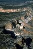 One of the largest roadless areas in Utah, this complex and colorful landscape is dominated by the thousand-foot-high White Cliffs, which divide high, forested benches from slickrock canyons and banded badlands. Located north of Highway 89 east of Kanab, Utah, and south of Henrieville on Highway 12, Paria-Hackberry links the High Plateaus with the designated Paria Canyon-Vermilion Cliffs Wilderness near the Colorado River. Together these areas form a wilderness travel corridor extending from Bryce Canyon National Park to Grand Canyon National Park, encompassing a complete vertical cross-section of the Grand Staircase.
Geology and landforms
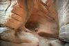
Two steps of the Grand Staircase are in this unit. The Vermilion Cliffs of deep-red Moenave Sandstone, with banded red, grey, and white Chinle badlands at their base, line the southern boundary and the lower eight miles of the Paria River. The remainder is in the White Cliffs of the Navajo Sandstone, except for the high mesas on the north and west boundaries, which are capped by the Carmel Formation. Some 25 miles of the shallow, silty Paria River cut through these cliffs and benches. Clear water flows in Sheep Creek, Hackberry Canyon, and several other perennial streams. These canyons are more than 1,000 feet deep in places and have sections of fine narrows. The unit is bounded on the east by Cottonwood Creek and The Cockscomb.Plant communities
The benchlands of Paria-Hackberry are covered with a pinyon-juniper forest, with areas of shrubs, sand dunes, and important relict grasslands on No Mans and Little No Mans mesas. Some ponderosa pine is found in higher areas, and cottonwood trees and associated riparian species grow along the more than 50 miles of streamcourses. The BLM notes the presence of Psoralea pariensis (Paria scurfpea), under review for possible threatened or endangered status. The unique relict plant community of pinyon-juniper and sagebrush-grass park vegetation on No Mans Mesa is accessible only by a steep, almost impassible trail. This mesa was grazed by goats for two years in the early 1900s, and is one of the few remaining unaltered plant communities in the state. The waist-high perennial grasses and thick cryptogam found here represent the natural, pre-grazing vegetative cover of much of Utah.Wildlife
Mountain lion and mule deer inhabit the unit, and the UDWR identified the southeast half of the unit as a peregrine falcon use area (see also area overview).Archeology and history
Pictograph and petroglyph panels are known in the unit, and there is a potential for significant cultural resources based on known sites elsewhere in the Grand Staircase area, according to the BLM.Recreation
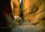
The Paria River, Hackberry Canyon, Sheep Creek, and Bull Valley Gorge are prime hiking routes (Kelsey, 1987; Hall, 1982). Loop trips can be made from one drainage to another by crossing the intervening benchlands. The Round Valley Draw, Stone Donkey Canyon, and Sam Pollock Arch are notable attractions, and the presence of perennial streams makes hiking relatively easy and accessible. This segment of the Paria River is not nearly so well known as the Paria Canyon narrows farther downstream, so solitude is easy to find. Cottonwood Creek and the ghost town of Old Paria are enjoyable destinations accessible by road just outside the proposed wilderness and offer spectacular views into the wilderness. The National Park Service has identified the Paria River as a potential wild and scenic river.BLM recommendation
Of its 135,822-acre WSA, the BLM initially recommended wilderness designation for only 59,270 acres, split into two separate units. The agency excluded 10,200 acres from its WSA claiming they lacked naturalness, and another 12,700 acres for supposed lack of solitude or primitive recreation opportunities. The excluded lands are in several separate parcels along the southern, western, and northern boundaries. Following public review of its draft recommendation, the BLM has indicated that it will add some 35,700 acres to its recommendation for a total of 95,042 acres. Much of the area excluded from the WSA, as well as WSA lands omitted from the final recommendation, are targeted for chaining and ORV use. Most of the excluded lands have "low potential" for oil and gas, and under the BLM's all-wilderness alternative, "the loss of development opportunity for uranium would not be significant" (BLM, 1986, p. 14). The BLM's final recommendation would split the unit in two along the Paria River, leaving the river canyon open to ORV use.The Paria Box, the spectacular lower canyon of the Paria River through the Cockscomb, was excluded to allow for a potential coal haul railroad (BLM, 1986, p. 10 and 22). The Paria River bed through the proposed wilderness was excluded from the draft recommendation to allow ORV use, even though current use is low and closure "would not be a significant impact" (BLM, 1986, p. 29 and 32). Although the BLM claimed that "the aggregate area of scenic values in its WSA is about 59,300 acres" (the area it initially recommended for designation), it rates 97,800 acres as Class A scenery (BLM, 1986, p. 19 and 22).
Coalition proposal
We recommend a single 158,700-acre Paria-Hackberry wilderness unit which will protect the most important natural features of this area, including the Paria River and its tributary canyons, the forested benchlands above the White Cliffs, and the ecologically significant No Mans Mesa.BRYCE ADJACENT UNITS
(Squaw and Willis Creek, East of Bryce, and Box Canyon)
Highlights
 Bryce Canyon National Park is renowned for its expansive vistas across the canyons and mesas of the Grand Staircase. Three BLM wild land units -- Squaw and Willis Creek, East of Bryce, and Box Canyon -- lie below Bryce's cliffs and form part of the scenic foreground of the national park. The BLM, however, dropped each of these units from wilderness study. Every other component of the Grand Staircase is at least partly protected in wilderness study areas. Wilderness designation would protect an important part of the view from the national park, hiking and horseback riding routes leading up into the park and adjacent national forest land, and important habitat for big game and songbirds. A dirt road leading from Cannonville to Alton separates the Squaw and Willis Creek unit from the Paria-Hackberry unit.
