THE BEHIND THE ROCKS WILDERNESS
- Arches Meets Canyonlands
- Speculative Hopes
- The Utah Wilderness Coalition Proposal
- GOLDBAR CANYON UNIT
- BEHIND THE ROCKS AND HUNTERS CANYON UNITS
- HATCH WASH UNIT
 The proposed 51,100-acre Behind the Rocks wilderness area is divided into four units: Goldbar Canyon, north of the Colorado River; Behind the Rocks and Hunters Canyon south of the river, separated by the Pritchett Canyon jeep way; and Hatch Wash still farther south and to the west of the Kane Springs Canyon road. The BLM dropped three of these units from wilderness study altogether and dropped contiguous natural areas from the fourth. The agency failed to exclude impacted areas from its WSA boundaries, exaggerated minor impacts, and subdivided contiguous natural areas along topographic lines.
The Utah Wilderness Coalition proposal would restore the natural boundaries of the Behind the Rocks area to meet the legal requirements for wilderness. The area concentrates geological and cultural features found in Arches National Park to the north and the Needles District of Canyonlands National Park to the south, providing outstanding backcountry recreation and solitude in first-class scenery immediately outside the town of Moab.
Arches Meets Canyonlands
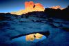
The Moab Rim is topped with domes and fins of Navajo and Entrada sandstones, with drainages cutting into the multi-hued Kayenta Formation and then the red cliff-forming Wingate Sandstone beneath. The concentration of arches in the proposed Behind the Rocks wilderness is similar to that in Arches National Park, with over 20 major, named arches and at least that number of unnamed arches known within the area, with more being discovered each year. As in Arches National Park, most arches are in the Navajo and Entrada. Unlike Arches, at least one large arch also occurs in the Kayenta Formation in the Goldbar unit, similar to the Cassidy and Hickman Arches in Capitol Reef National Park.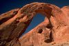 The top of Goldbar Canyon, Hunters Canyon, and Hatch Wash bears a remarkable resemblance to the area of Capitol Reef National Park traversed by the Frying Pan Canyon Trail between Grand Wash and the Fremont River. Potholes abound in the tops of Navajo Sandstone domes and smaller canyons. There are exposures of Navajo fins in the Klondike Bluffs area of Arches National Park, but the area of fins dominating Behind the Rocks is much larger.
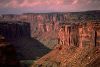
Where canyon drainages penetrate the Wingate Sandstone, pouroffs form into 400- to 1,000-foot-deep, sheer-walled canyons, often exposing perennial springs at the bottom of the Kayenta Formation. Lower Pritchett, Hunters, Kane Springs, and Hatch canyons penetrate the Wingate, with only Pritchett lacking perennial water.
Behind the Rocks was inhabited extensively by the Anasazi and Fremont Indians, the two cultures apparently overlapping here. Petroglyph panels, habitation caves, stone ruins, and chert-knapping middens abound throughout the area, as they do to the south in Indian Creek and Salt Creek in the Canyonlands area.
Because the deep canyons are sinuous and typically thick with riparian vegetation while the majority of the country is a whimsical labyrinth of domes, fins, arches, spires, and potholes, one rarely encounters other visitors. It is rare to find a natural area with as much geological and cultural interest so close to a town with extensive visitor facilities. One can spend weeks in Behind the Rocks exploring new routes amid real solitude.
Speculative Hopes
Why did the BLM overlook the wilderness values of the Behind the Rocks, dismissing most of the qualifying lands from the wilderness inventory?Around 1979, when the BLM dropped 7,365 acres from the Behind the Rocks WSA and dropped the remaining units from wilderness consideration, the nation was in the throes of an energy crisis. The "Sagebrush Rebels," those opposed to federal control of public lands, had captured the local political structure. Oil and gas exploration roads were approaching the wilderness across Flat Iron Mesa and Hatch Point in the south and in the Little Canyon drainage to the east. Moabites staked mineral claims all over exposures of Navajo and Kayenta formations, despite the fact that the uranium-bearing Chinle Formation was a thousand feet down and the potash-rich Paradox Formation was over three thousand feet down. Moreover, the country was too rough for surface access to do exploratory drilling, much less profitable extraction if any commercial-grade deposits were found.
Wilderness designation, which would limit such speculation, was viewed with overt hostility. In the Moab area, the BLM coordinator for the wilderness inventory was married to the geologist for a mining company who also had thousands of claims filed in his own right and was the president of the local off-road vehicle club. Conservationists soon noted how the BLM's claims of a lack of wilderness values coincided with areas in which this individual had mineral or ORV route interests.
 For the three units dropped from the wilderness inventory, the BLM cited impacts from mineral exploration roads on the relatively accessible areas to the south, west, and east of the units but did not adjust the boundaries to embrace natural areas too rough for roads to penetrate, excluding the areas with substantially noticeable impacts, as the Utah Wilderness Coalition has done in this proposal. ORV routes over slickrock -- which are rarely noticeable even on the ground -- were called "roads." These exaggerated impacts were used to disqualify part of the Goldbar Canyon and split off the northern portion of the Behind the Rocks unit. A largely invisible, abandoned drill road (located half on slickrock) and the presence of two state sections were used as rationale for dropping Hunters Canyon. The entire east face of the Moab Rim was dropped from the Behind the Rocks unit on the dubious rationale that, being a vertical cliff from which one could see the Moab Valley, it did not offer solitude and other wilderness values.
Claims of resource conflicts in the Behind the Rocks area rest on fantasy. The proposed wilderness units are ringed with dry oil and gas holes. Any extractable minerals underneath the units, however rich, face formidable costs for exploration and extraction and cannot compete with other, non-wilderness areas with equivalent mineral resource potential. Most of the topography is too rough for a horse or mule, much less a motorized vehicle.
The Utah Wilderness Coalition Proposal
The four units of our 51,100-acre Behind the Rocks proposed wilderness would protect outstanding recreational, geological, cultural, and riparian wildlife resources and form a bridge between Arches National Park to the north and the Needles District of Canyonlands National Park to the south. The wilderness would be a strong recreational asset for the Moab area and all of Utah.GOLDBAR CANYON UNIT
Highlights
Northwest of Moab, where the Colorado River flows through the cliffs of The Portal, the 12,500-acre Goldbar Canyon unit is set into a great bend of the river. Its north edge lies west of Arches National Park across Highway 191, and it shares the character of the park, containing several major arches. Goldbar Canyon completes the stretch of wild land from Arches to Behind the Rocks and Hunters Canyon south of the river.
Geology and landforms
Goldbar Canyon lies in a syncline, dipping in the middle and sloping gradually up on the east and west. The Navajo Sandstone crops out over most of the unit and is eroded into slickrock terraces, fins, and arches; the deeper canyons expose the Wingate Sandstone and the Kayenta Formation. Soils in the unit are classified in the critical erosion class, according to the Grand Resource Management Plan (BLM, 1983), creating hazards for potential development. Among the spectacular arches are Corona (sometimes called Little Rainbow Bridge, although it is not a true natural bridge), Bowtie, Little, and Jeep. A number of unnamed arches, natural bridges, and tunnels are found in the upper branches of Goldbar Canyon.Plant communities
Mostly bare slickrock, the unit also supports pinyon pine and juniper as well as some blackbrush. Riparian growth winds along the bottoms of both Day and Goldbar canyons, and some hanging gardens color the canyon walls where seeps trickle down.Wildlife
Bighorn sheep frequent the unit and are sometimes seen grazing on the cliffs and grassy areas above Highway 191. Mule deer also make their homes here, and coyotes, cottontails, foxes, and a variety of lizards inhabit the unit. The steep-walled canyons provide good nesting sites for raptors.Archeology and history
In the southeast of the unit, near the Poison Spider jeep trail, is a rock slab of the Kayenta Formation imprinted with dinosaur tracks. (The Moab Chamber of Commerce has established a viewing point along Highway 163.) Also present in the southeast are petroglyph panels and several caves used by the Anasazi from which artifacts have been excavated. No archeological inventory of the unit has been completed.Recreation
Easily accessible from Highways 163 and 279, Goldbar Canyon provides numerous hiking opportunities in rugged terrain. F.A. Barnes (1977), in Canyon Country Hiking and Natural History, describes hikes to Corona and Bowtie arches as well as on Poison Spider Mesa, and also mentions several arches in his 1987 book Arches and Bridges. This is a good place to explore for unusual geological formations. High points in the unit offer panoramic vistas of the Colorado River gorge and Arches National Park. The maze of slickrock fins across the river in the Behind the Rocks unit is a breathtaking sight, and the feeling of solitude so close to Moab is quite remarkable.BLM recommendation
The BLM did not study Goldbar Canyon for possible wilderness designation, beyond a cursory examination that focused on a few areas of impacts that are deleted from our proposal.Coalition proposal
Our boundary excludes zones of human disturbance, including regularly used roads, two reservoirs, a landing strip and associated structure, two pipelines, three transmission lines, and popular mountain bike routes. There is a railroad tunnel beneath Poison Spider Mesa, but the undisturbed surface above the tunnel is included in our proposal. The most heavily used part of the jeep/mountain bike road onto Poison Spider Mesa is cherrystemmed from our proposal. The remaining 12,500 acres retain their pristine character. Designation of these wild lands would provide a "natural bridge" between Arches National Park and the Behind the Rocks and Hunters Canyon units, enhancing the wildness of the entire area.BEHIND THE ROCKS AND HUNTERS CANYON UNITS
Highlights
Just beyond the 1,800-foot-high rim to the southwest of Moab lie almost 25,000 acres of Navajo Sandstone fins. These rock walls shelter narrow, secret desert gardens that invite discovery on foot. Easy access from Moab (via Highway 163 along the Colorado River and the Pritchett Canyon jeep way, which splits the two units) gives Behind the Rocks and Hunters Canyon special value to this recreation-oriented community.Geology and landforms
Primarily exposed and eroded Navajo Sandstone, Behind the Rocks is a "50 square mile labyrinth of slickrock fins and domes, arches, giant caverns, sand dunes, deeply cut canyons and lofty rimlands...." (Barnes, 1977). The fins that dominate Behind the Rocks run from east to west and provide natural screening that creates a feeling of overpowering solitude. The fins extend west across Pritchett Canyon into the Hunters Canyon unit, giving way to the contorted domes, ledges, and numerous small canyons of the Kayenta Formation before reaching the sheer Wingate cliffs in Hunters and Kane Springs canyons. With rugged terrain and panoramic views of the Colorado River and southeastern Utah, these units offer a close look at unique erosional forms.Plant communities
Pinyon pine and blackbrush grow between the bare rock fins, as well as some juniper and scattered riparian species, notably in Hunters Canyon. Hanging gardens are found at seeps, particularly in Hunters Canyon. The BLM lists three sensitive species: the milkvetch Astragalus isleyi, the milkweed Asclepias cutleri, and the death camas Zigadenus vaginatus.Wildlife
The unit provides habitat for an impressive variety of wildlife. The BLM lists mule deer, coyote, bobcat, cottontail, chukar, and occasional cougar and desert bighorn sheep; the cliff faces provide nesting habitat for a number of raptors including red-tailed hawk, great horned owl, prairie falcon, and kestrel. Peregrine falcon are found in Hunters Canyon, according to the UDWR; golden eagle may also visit the units.Archeology and history
The units are rich in history and prehistory. Five archeological sites have been reported in Behind the Rocks; the BLM estimates that six times that many sites may exist. A likely candidate for inclusion in the Register is the "Indian Fortress," which covers some five acres and includes much fine rock art and several historic inscriptions. A rock slab of Kayenta Formation is imprinted with dinosaur tracks in this area. Another interesting set of historic graffiti is found near Otho Arch, one of at least four spectacular natural arches found in the unit. The Old Spanish Trail is visible to the east from the Moab rim.Recreation
The character of Behind the Rocks ranges from quiet, private canyons among the Navajo Sandstone fins, to vantage points on the Moab Rim that command panoramic views of southeastern Utah. Day hikes are especially popular here; short backpacks are possible, but water sources are few. Suggested hikes in Behind the Rocks and Hunters Canyon can be found in Barnes (1977), Hall (1982), and Kelsey (1986a). Rock climbs and scrambling are possible here. Not published are innumerable routes through a labyrinth of beautiful erosional forms between Hunters Canyon and Pritchett Canyon. These canyons are accessible from the jeep way along Pritchett Canyon or by a route from Tunnel Arch or Moonflower Canyon out of Kane Springs Canyon.BLM recommendation
The BLM recommends wilderness for its 12,635-acre Behind the Rocks WSA. However, the agency dropped 7,365 acres from that unit in its initial inventory and dropped all of Hunters Canyon. The agency failed to draw a boundary that excluded the obvious impacts, and it downrated areas used by ORVs. The scenic eastern cliff viewed from Moab, as well as the northern cliff where the Colorado River enters The Portal, were deleted after the BLM split the inventory unit along a cliff face, claiming that the area just below the cliff rim lacked outstanding opportunities for solitude and primitive recreation. The northern part of the deletion was made to accommodate an ORV route over solid sandstone. The route cannot be followed without cairns; it is an insignificant intrusion on the landscape.Coalition proposal
We propose 20,300 acres of wilderness in the Behind the Rocks unit and 4,000 acres in the Hunters Canyon unit. Both units qualify for wilderness designation, and their unique scenic, geologic, and archeologic features deserve protection. Our boundary includes the northern portion and eastern cliff of Behind the Rocks that the BLM deleted from study. The ORV route to the rim is part of a designated BLM hiking trail to Indian Fortress and Hidden Valley and should be limited to non-motorized use. Back of the Moab Rim, vegetated areas of blow sand between rock formations are being indiscriminately sterilized by ORV wheels.HATCH WASH UNIT
Highlights
Hatch Wash lies about 20 miles south of Moab. Thirty miles of deep, twisting canyons wind though the unit, and lovely riparian vegetation borders the clear perennial stream that flows the length of the main canyon. Hatch Wash forms an isolated area of high recreational potential just east of Canyonlands National Park.
