Greater Dinosaur/Book Cliffs Heritage Plan
Heritage Plan Maps
Route/Recreation Plan Pie Charts
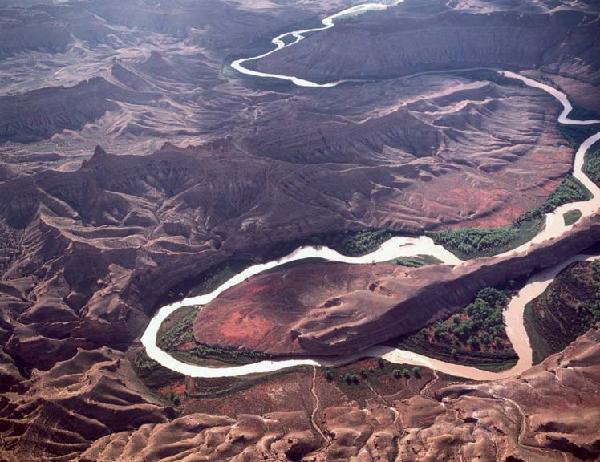 |
| Aerial view of the White River. Copyright Steve Mulligan. |
South of the Greater Dinosaur area lies the White River canyon. The White River is a perfect example of how a river brings life, beauty, and diversity to the desert landscape. From atop the ridges to the south of the river, one can appreciate the lush green ribbon of life that the river provides in the midst of an arid desert.
Still farther south lie Bitter Creek, Dragon, Seep, and Sweetwater Canyons, Wolf Point, and several other wild and remote landscapes deserving of federal protection. These areas are part of the Book Cliffs ecosystem a diverse expanse of high forested mountains and canyons that provide important habitat for elk, black bear, mountain lion, and other wilderness species. In fact, this is one of Utah’s most important sanctuaries for wildlife.
With wild and undeveloped landscapes disappearing rapidly in this area and across the planet, it is no wonder that more than 250 conservation groups nationwide consider preservation of the wild, primitive, undeveloped character and biological integrity of the Colorado Plateau and surrounding regions to be one of their primary goals. The purpose of this Greater Dinosaur/ Book Cliffs Heritage Plan is to provide the BLM with a reasonable management alternative that strikes a balance between oil and gas development, off-road vehicle use, and the protection of our nation’s natural heritage.
Oil and Gas
According to USGS and Department of Energy studies, 95% of Utah's oil and gas production comes from a few already developed fields. Geologists agree that there is no significant chance of an energy bonanza outside of these already developed areas. If all proposed wilderness lands in Utah were filled with drill pads, it would extend our national oil supply by about 4 days and our natural gas supply by about 24 days. See Analysis of Utah Oil and Gas Production, Leasing, and Future Resources, by Mark Lemkin. This is clearly not a significant contribution to our national energy needs. Yet the BLM continues to encourage exploration and development in these sensitive areas, sacrificing world-class scenery, wildlife habitat, recreation, and wilderness in order to develop third-rate oil and gas deposits. No reasonable person would consider this a balanced policy.
In the citizens’ heritage plan alternative, the Greater Dinosaur/Book Cliffs proposed oil and gas policy is quite simple: oil and gas development could continue in and near productive areas, but would not be permitted in areas where recreational, scenic, wilderness and/or wildlife values outweigh marginal oil and gas resources (see attached Oil and Gas map). Under the Greater Dinosaur/Book Cliffs Heritage plan, approximately 75% of the lands managed by the Vernal BLM (as opposed to 93% percent in the BLM’s preferred alternative) would be available for oil and gas leasing and development. Protecting about 25% of the area’s spectacularly scenic, wildlife-rich lands is NOT an outrageous proposition, and would help provide the public with a more balance, multiple-use management plan.
Off-Road Vehicles
The Vernal BLM does not intend to complete a travel management plan as part of the planning process. Rather, the Vernal field office intends to designate for vehicle travel all of the routes appearing in data that the counties provided to the agency, without assessing the impacts of motorized use on these routes and the conflicts such use will have on wildlife and other recreationists. Many miles of routes in the BLM's draft plan travel through lands the agency itself recently found to have wilderness characteristics. The Vernal office plans to do this despite the fact that the BLM is mandated to designate routes that minimize conflicts with resources and users.
The BLM should develop a sensible, evenhanded transportation plan based on the following principles:
- Vehicles should be restricted to designated roads and trails throughout the entire resource area no "open" ORV play areas (with the possible exception of certain small, manageable areas that do not conflict with other resource values). Even some off-road vehicle advocacy groups agree that unrestricted driving off of established routes is no longer acceptable. (This does not mean that there cannot be ORV-emphasis areas where there is a high density of designated routes.)
- All routes should serve some identifiable purpose. If there is no compelling reason for a route to stay open, then it should be closed. (For example, ORV trails and old cow trails that lead to nowhere should be closed.)
- The transportation plan must continue to make sense until the next management plan revision, 15 to 20 years from now. Use levels will almost certainly be much higher then. Any routes designated open now will almost certainly see very high use levels in the future, so these routes must be capable of sustaining high use without causing ecological damage or ruining the peace and quiet that most visitors come here to experience. There need to be adequate opportunities for both motorized and non-motorized recreation, while avoiding conflicts between these two groups.
- Many of the most pervasive threats to biological diversity habitat destruction and fragmentation, edge effects, exotic species invasions, pollution (noise, petrochemical, and heavy metal), sedimentation, and over-hunting are exacerbated by the existence of roads. According to the BLM’s own studies, the existence of roads clearly exacerbates the threats and vandalism to the world-class cultural resources of Southern Utah. In order to facilitate enforcement, there should be a "closed unless signed open" policy. The large majority of visitors to the area want to obey the law and stay on designated trails. This policy makes it very easy for visitors to determine what's legal and what's not.
- As use levels increase, combining non-motorized and motorized users on the same trail system becomes unacceptable. No one likes hiking, mountain biking or riding horses on a trail crowded with motorcycles and ATVs. There needs to be a fair allocation between motorized and non-motorized users.
- Ecologically damaging routes, such as routes through riparian areas or important wildlife habitat, should be closed.
- There need to be adequate opportunities to get out of earshot of motorized trails. Currently, the large majority of lands managed by the Utah BLM are within 1 mile of a motorized road or trail. This is not acceptable in Southern Utah, one of the most remote and unspoiled parts of the lower 48. Therefore, many routes which penetrate deeply into otherwise roadless areas should be closed in order to provide a more balanced spectrum of near-road and far-from-a-road recreational opportunities.
Wilderness lands account for 25% of the public lands within the Vernal planning area. The Greater Dinosaur/Book Cliffs Heritage plan would help ensure that the public can continue to enjoy camping, river-running, fishing, hunting, walking, wildlife viewing, and other traditional activities on these lands without the disruptive sights and sounds of vehicles or industrial development.
